On the way out of Chisasibi we took a quick detour to see LG1, one of the great hydroelectric dams of northern Quebec. My eyes don’t see well at dusk, so it was a fine time to get off the bikes for a few minutes. We soon discovered that we could ride across the top of the dam, and then to a viewing platform downriver. It is hard to capture the scale of the barrage, but it is 1.3 kilometers wide and 160 meters in height.
Downstream at Le Grande

LG-1

The sun completely down, we set off for the JBH. By the time we reached the highway I was freezing. The temperature had dropped close to freezing, which makes it several degrees colder at speed. We stopped to regroup, adding whatever layers we had. We also used the last of our heatpacks. It was ultimately all for not. Within 100 kilometers I could barely keep my legs from shaking, and my speed was dropping continuously, a tell-tale sign of fatigue. Soon after that I was convinced I could see frost on the trees, and the miles rolled by dreadfully slowly. What seemed like an hour would pass and we’d be just ten kilometers closer to our goal. The steady stream of northbound logging trucks soon proved a hazard, as I began to fear drifting across lanes, especially as it became more difficult to hold our lines through the corners. Then, at km 470, we hit a fog which swallowed our front wheels. It was only with good fortune that we were alongside Lake Mistanikap, dotted with Cree summer camps. We set up camp as quickly as we could. Chilled to the core, I slept in all my gear.
I woke up late the next morning. It had been an awful ride the night before. And today we had 1100 kms to home. Still, I looked forward to the challenge. Even when I pushed my head outside of the tent and proceeded to cough up a bunch of blood.
The camp in morning

We tried to be efficient in cleaning up camp, but the long night had gotten the better of us. Sam dropped his bike in the sand twice. I almost dropped mine once (and had dropped it twice the day before). But we soon resolved ourselves to the task and set out. We rode a hard pace to Relais 381 where we would gas up for our longest stretch yet without fuel. Then, filled up on some mixture of Red Bull, ginseng, and Gatorade, we headed for Matagami. It’s hardly heavy fuel, but it will keep you eyes up on the bike.
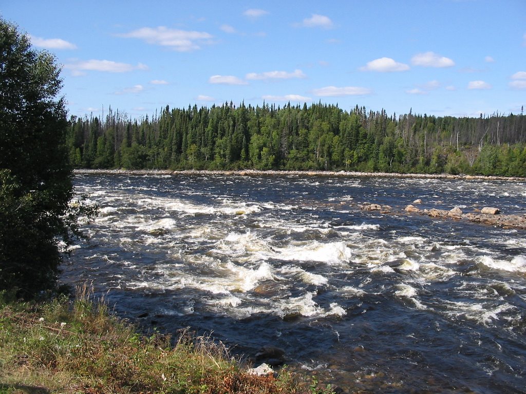
At km 257 we finally hit the Rupert. We had crossed it earlier on the North Road, but there the river was nothing like it is here. By the time the Rupert crosses the JBH is has collected much more water, as several more lakes spill into its stream. I had seen pictures before, but they did nothing to capture the scale of the rapids. It takes little to imagine the most calm line leading to smashed canoes. And it is inconceivable that one could run the roughest section of the cataracts. This is, quite literally, a deadly river. It is a kilometer of crashing. crushing rapids. There is nothing calm or serene about it. The Queen of the North, it is one of Quebec’s greatest possessions. As I’ve written below, this is not for much longer. Sam and I briefly discussed the merits of damming the river, given how much power it will provide and how much wealth will accrue to the Cree nations as a result. But it really doesn’t make up for the loss. We had little time to stay – we had to get back to jobs and studies. Life rolls on like the Rupert, apparently. Until it doesn’t.
The Rupert River

From the Rupert we rode a little less than 900 kilometers home. I rode about 80 more than Sam, on account of his bike breaking down in the Gatineaus. The cause remains unknown, despite he and I performing a number of simple tests on the roadside, guided by my dad on a cellphone. I ended up winding the last 80 kilometers home following a tow truck with Sam’s bike. It was a poor ending to an extraordinary trip, the thoughts of which keep flowing.
2 comments:
I just came across your excellent blog while searching for info on trips to the JB area; I'm studying that sort of thing and would like to see the dam for myself rather than simply analyzing its historical impact from Fredericton/Ottawa. Do you have any advice for someone who wants to travel up there or work in the area this Spring and Summer? Thanks!
Anne: when I was planning my trip, the best site was Walter Muma's (http://jamesbayroad.com/index.html).
Generally speaking, it's easy to get up to the dams, if only a rather long and isolated drive. If one drives straight up from Matagami it is a well-paved road the whole way. However, if you want to see the dams farther inland you have to be willing to brave the Trans-Taiga, which is both more isolated and gravel.
Don't hesitate to send me any more questions or email me at pjlwn@mta.ca
Post a Comment